 |
Audio Asylum Thread Printer Get a view of an entire thread on one page |
For Sale Ads |
|
|
Audio Asylum Thread Printer Get a view of an entire thread on one page |
For Sale Ads |
203.129.41.119
;-)!
WarmestTimbo in Oz
The Skyptical Mensurer and Audio ScroungerAnd gladly would he learn and gladly teach - Chaucer. ;-)!
'Still not saluting.'

Follow Ups:
I am glad you enjoy hiking. It is a great form of exercise.
If you like climbing up and down hills have a look at the link
below of one the most beautiful places on earth...IMHO.
Growing up in rural WV, I was surrounded by mountains and
spent many hours hking about and exploring. When I was a youngster
we used to vacation at state parks in the Monongahela
National Forest. It has some of the most dense mountain ranges
in the US and it is absolutely beautiful. Spend some time on the
website looking at the various places to visit.

I too grew up in "rural" WV. My father was born and raised in a place named Fayetteville, which is not far from Cranberry Glades. We camped and hiked there often.Many fond memories of that wonderful place. Been in the Monongahela forest many many times. We also used to camp at the convergence of the Greenbrier River and Anthony Creek on a very terriffic spit of land where the two bodies of water meet. Very picturesque place.
thanks for the reminders
roN

Hey Ron,We used to camp at Summit Lake and drive over to that spot where you
could park and either ride a bike or hike down to the Cranberry
River. We used to walk down and fish along the river. I still remember how
good the Trout tasted that we caught from that river.
I never got to fish the Williams or the Cherry rivers. Speaking of the
Greenbrier river....we used to fish on it as well and I
attended a summer camp along the Greenbrier River called
Camp Thomas Lightfoot. It was a summer camp setup for children
of Eastern Associated Coal Company employees. It was located
up Route 3 out of Hinton toward Pence Springs.This brings back some good memories....

do-able I'd reckon iffen's I had known more of yez!And I coulda met BWOOCE at LA!
WarmestTimbo in Oz
The Skyptical Mensurer and Audio ScroungerAnd gladly would he learn and gladly teach - Chaucer. ;-)!
'Still not saluting.'

Like OUR Hume & Hovell track?I will have 'a bit of a captain cook', right now!
Tah and stuff!
WVA was created a State during the CW, I knew that, and why?! bE PROUD OF IT!
;-)!
"The green rolling hills of West Virginia,
Are the nearest thing to heaven that I know'If they're better/greener than the drive to Antietam in Summer then they must be beautiful!
WarmestTimbo in Oz
The Skyptical Mensurer and Audio ScroungerAnd gladly would he learn and gladly teach - Chaucer. ;-)!
'Still not saluting.'

West Virgina is *SO* rural, this is how they get their TV. :-)Even their Naval Base (Sugar Grove) is nowhere near the water.
Neil

An old joke amongst West Virginians is that you will find many
old 6 foot C Band Satellite dishes still back in the hills.
Years ago and even today there are still areas where
there is no TV cable. We refer to the old dishes as the
WV State Flower.... ;-)"Urban" is a relative term I guess, depending upon what part
of the state you are in. The corridor between Charleston and
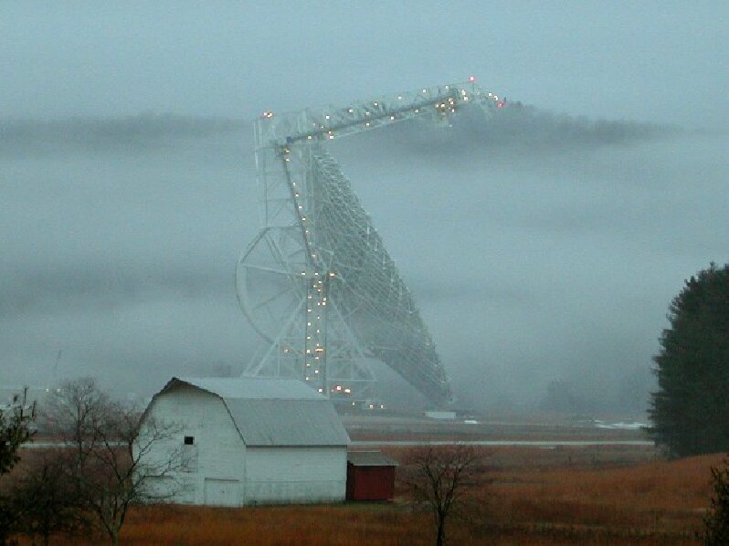
Huntington are about as "Urban" as it gets for WV.I visited the observatory once and took the tour. They had just
completed building the dish that is about the size of a American
Football field. The really bizarre thing from what I remember is
the location of the observatory. It is in a VERY rural area with
small townships. I remember the drive there was on a long windy
2 lane road. I remember it was quite startling when you enter the
facility and see all of the huge dishes considering the locale.

My sister lives in WV (Franklin) and has been there for several years after living across the state line in Harrisonburg, VA for many years. She had a lot of WV jokes that she had to give up now that she is one of them.I've been down to visit twice in the last year or two and it certainly is "The Mountain State". Absolutely a beautiful area, but it's a long way to anything, and there is at least one mountain to go over to get there. Among the several stops along the sightseeing tour was Greenbank. That sucker us huge, and what was amazing is that they moved it while we practically standing next to it and you could barely hear it. Also went by Sugar Grove. According to my brother-in-law, it is becoming less Navy and more CIA (or some other agency). All your overseas calls to the middle east are probably monitored here. :-) He had done some work on the base with a local contractor and most of the operations are inside the mountain.
Neil

I am always pleased when I hear about anyone of "mature years" that regularly get themselves out of their cars and takes genuine excercise... I have the general feeling that lots who - with the memory of youth? - may instinctively feel that your walk sounds not much more than "a leisurely stroll" may find themselves gasping and embarrassed if they actually tried to emulate you "crusties"!With technology making all lives much "easier", the lifestyle of many will, IMO, be likely to leave folk rather less fit and conditioned at the same age-points than their predecessors...
For those who do not have the day-to-day requirement of excercising very active dogs up to three times each day, walking groups such as yours would probably be one of the better ways of ensuring that the body does not (prematurely) go to seed...
I hope you have had a thoroughly enjoyable week-end...
Bill.

it looks more like what we call a "hill" as in Berkshire Hills. No offense intended
"Man is the only animal that blushes - or needs to" Mark Twain

The climb is 270m by 3.28 or 900 feet, and the walk is about 3km up and back.It IS the highest of the peaks actually withIN the several urban spreads that are Canberra. And the views are spectacular.
Iffens / when any of yez visit Canberra - and have the sense ter tell me, and we have time for it - you WILL be doing the very same walk. 'Cos it is the easiest, and IMO best, of the several, and you can see MOST of Can'tberra from it and most of the ACT including the Australian Alps!*
The last two pitches on OUR route up the SW face are steep, this side is VERY steep, it's mostly a traverse walk.
On this SW-ern side there are CLIFFS down which people have fallen to their deaths, and which the two piccies can't show. It is also the only wooded / native plants part. The rest was heavily cleared and grazed. I'd done a bit of research so I could identify some of the rare flora in that section, to the group, some are listed as threatened and only barely survived the 2003 fire-storm!
But, yes it was a very short walk compared to most of the groups walks, and it kinda naturally fitted in. ? Rain WAS predicted so the numbers were low. When we are up there a strong norteherly had reached almost gale force so we had to get down onto the Southern lee for morning tea. Yet throughout that time I was watching the rain clouds building UP to the South! it began raining not LONG after we got back home.
#The height I live at is sufficient to reduce the amount of yeast I need for bread, by around a fifth!
*In the piccie taken from Pearce you can see a line of snow-covered hills behind it!
WarmestTimbo in Oz
The Skyptical Mensurer and Audio ScroungerAnd gladly would he learn and gladly teach - Chaucer. ;-)!
'Still not saluting.'

and I really didn't mean to be a smartass. I grew up in the Berkshire "Hills" which are part of the upper end of the Appalachian Trail. Not far from Mt. Greylock. We are also surrounded by the Adirondack "Mountains", the Green "Mountains" and the Catskill "Mountains" but the best we could do in the Berkshires was "Hills"
"Man is the only animal that blushes - or needs to" Mark Twain

avva hug maaate. Didn't fink yez was, s'more that I knew what wide angle standard lenses DO, see!Mt Greylock is 1,064 Metres high!
i have a hill to climb whenever I want!
WarmestTimbo in Oz
The Skyptical Mensurer and Audio ScroungerAnd gladly would he learn and gladly teach - Chaucer. ;-)!
'Still not saluting.'

This post is made possible by the generous support of people like you and our sponsors:
